Broken Hill
Type of resources
Keywords
Publication year
Topics
-
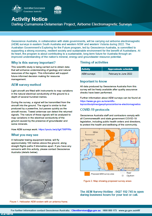
Geoscience Australia, in collaboration with state governments, will be carrying out airborne electromagnetic (AEM) surveys in eastern South Australia and western NSW and Victoria during 2022. The Australian Government’s Exploring for the Future program, led by Geoscience Australia, is committed to supporting a strong economy, resilient society and sustainable environment for the benefit of Australians. At its heart, the program is about contributing to a sustainable, long-term future for Australia through an improved understanding of the nation’s mineral, energy and groundwater resource potential <p>
-
Google has partnered with hundreds of museums, cultural institutions and archives including Geoscience Australia to host treasures from our National Mineral and Fossil Collection online on the Google Arts & Culture website. Our building's public areas have been scanned and are online via a streetview virtual tour, there are a large number of collection items uploaded which have been used to create many unique and fascinating exhibits.
-
<div>The Curnamona Province and overlying basins (herein referred to as the Broken Hill region) contain many discrete groundwater systems. These include sedimentary aquifers of the Lake Eyre Basin, Eromanga Basin, Darling Basin and Arrowie Basin, as well as fractured rock aquifers of the Adelaide Superbasin and Curnamona Province. However, there is little known about the hydrogeology or hydrogeochemistry of these aquifers in the Broken Hill region. Given the semi-arid climate in this region, understanding these groundwater systems can better support sustainable use of the groundwater for agriculture, mining and potable water supplies.</div><div> </div><div>Aquifer attribution provides a fundamental starting point for any hydrogeological study. We will present recently released hydrogeochemical data for the Broken Hill region, and our subsequent process for assessing and attributing hydrostratigraphy to the samples. </div><div>The Broken Hill Groundwater Geochemistry dataset (BHGG) was recently released in its entirety (Caritat et al. 2022 http://dx.doi.org/10.11636/Record.2022.020). It contains a compilation of archival CRC LEME hydrochemistry data that was collected as part of several projects from 1999 to 2005. This high-quality dataset contains 275 groundwater samples and includes a comprehensive suite of majors, minors, trace elements and stable isotopes (δ34S, δ18O, δ2H, δ13C, 87Sr/86Sr, 208/207/206Pb/204Pb). </div><div> At the time of collection, some key bore metadata (e.g. bore depths, screen and aquifer information) were missing from the original data compilations and these metadata are crucial for any hydrogeological analysis and interpretation. Therefore, as part of the new BHGG data release we have developed a robust and consistent approach to add bore information and aquifer attribution, value-adding to the original BHGG chemical and isotopic data. This workflow utilises a combination of State databases, reports, field notes, drillhole compilations and geological maps, but still relied on local hydrological expertise to make decisions when encountering incomplete or conflicting information (which is reflected by a confidence rating on the attribution). </div><div> The resulting BHGG product has supported re-assessment of the key hydrogeological and geochemical knowledge gaps in each groundwater system. An overview of knowledge gaps and the new sampling program being undertaken will be included in the presentation. </div><div><br></div>This Abstract was submitted/presented to the 2022 Australasian Groundwater Conference 21-23 November (https://agc2022.com.au/)
-
The Upper Darling Floodplain AEM Survey is part of the Exploring for the Future Program. This scientific research is being carried out to obtain data that will enhance understanding of the groundwater resources of the upper Darling River region. This information will support future water resource management decision-making in the region.
-
<div>A groundwater chemistry, regolith chemistry and metadata record for legacy geochemical studies over the southern Curnamona Province done by GA and partners as part of CRC LEME from 1999 to 2005, that was never fully released. This includes comprehensive groundwater chemistry from more than 250 bores in the Broken Hill region, containing physicochemical parameters, major and trace elements, and a suite of isotopes (34S, Pb, Sr, 18O, D). Recent work on this dataset (in 2021) has added hydrostratigraphic information for these groundwater samples. Also included is a regolith geochemistry dataset collected adjacent to some of the groundwater bores which tests the geochemical response of a range of different size fractions, depths and digests.</div>
-
A comprehensive compilation of rock, regolith and groundwater geochemistry across the Curnamona Province and overlying basins. This product is part of the Curnamona Geochemistry module of GA's Exploring for the Future program, which is seeking to understand geochemical baselines within the Curnamona Province to support mineral exploration under cover. Data is sourced from GA, CSIRO and state databases, and run through a quality control process to address common database issues (such as unit errors). The data has been separated by sample type and migrated into a standard data structure to make the data internally consistent. A central source for cleaned geochemical data in the same data format is a valuable resource for further research and exploration in the region.
-
As part of the program, the Darling-Curnamona-Delamerian project is investigating the groundwater potential of the upper Darling River floodplain, as well as the mineral and groundwater potential of parts of eastern South Australia, western New South Wales, western Victoria and western Tasmania. Communities, industries and the environment in the upper Darling River region have been impacted by recent droughts. During periods of low flow in the Darling River, groundwater has the potential to be an alternative water source for towns, agriculture and mining. The aim of the Upper Darling River Floodplain Groundwater study is to identify and better understand groundwater supplies beneath the floodplain and its surrounds. When combined with innovative water storage options, these groundwater resources could provide enhanced drought security and promote regional development. The study area covers ~31,000 km2 and includes a 450 km stretch of the Darling River floodplain from Wilcannia upstream to Bourke and Brewarrina.